

Floods & Landslides – Savinja Region


High-resolution geospatial backbone
LiDAR, orthophoto and building data provide the spatial fundation for the analysis.

Landslides scenarios
Runout models for different slip-surface depths (0 m, 5 m, 20 m).

Flood impact comparison
Hydraulic simulations compare baseline and obstructed-channel conditions.

Better decisions
Identify hazards, assess imparts and support faster scenario-based decision-making.
Potential landslide runout for different landslide slip-surface depths
Comparison of scenarios with assumed landslide slip-surface depths of 0 m, 5 m and 20 m. A greater assumed depth represents a larger potential volume of incorporated material and may result in greater landslide runout.
The scenarios show the potential runout of a landslide under different assumptions regarding the depth of the slip surface. Three scenarios are presented: 0 m, 5 m and 20 m. The depth of the slip surface affects the amount of material that can be incorporated into the landslide and, consequently, its potential spatial extent.

0 m – Surface scenario
The 0 m scenario represents a surface scenario in which mainly the movement of material at the ground surface is modelled. The assumed volume of material is therefore the smallest.
5 m – Moderate-depth scenario
The 5 m scenario represents a condition in which material down to approximately 5 m below the ground surface can be incorporated into the landslide. Due to the larger available volume of material, the landslide may have a greater runout.
20 m – Deeper scenario
The 20 m scenario represents a deeper scenario. A substantially larger volume of material can be incorporated into the model, and therefore the landslide may travel a greater distance and affect a larger area.

What does slip-surface depth mean?
The slip-surface depth is the depth below the ground surface along which the landslide material is assumed to move. The greater the assumed depth, the larger the volume of material that can potentially be incorporated into the landslide.
Important: The depth itself does not mean that a landslide will actually be triggered to that depth. It is a modelling assumption used to assess how the potential runout and extent of the landslide process may change with different amounts of available material.
Key result
As the assumed slip-surface depth increases, the potential volume of material that can be incorporated into the landslide also increases, which may result in a greater runout distance and a larger affected area.
What happens when landslide material enters the river channel?
In the next step, the potential impact of the landslide was incorporated into the hydraulic model of the Savinja River. The aim was to assess how landslide material entering the river channel may alter flow conditions and consequently affect flood hazard.
In the first scenario, the existing terrain configuration is used without additional landslide material in the river channel.
This scenario represents the reference condition, in which water flows through an unobstructed channel and floodplain.
In the second scenario, landslide material deposited within the river channel is incorporated into the digital terrain model.
This changes the geometry of the channel and reduces the available space for water flow. As a result, flow velocity and direction, water level and the extent of flooding may change.
Compare the two flood scenarios
The comparison allows users to directly observe where and how landslide material changes flow conditions and the extent of flooding.
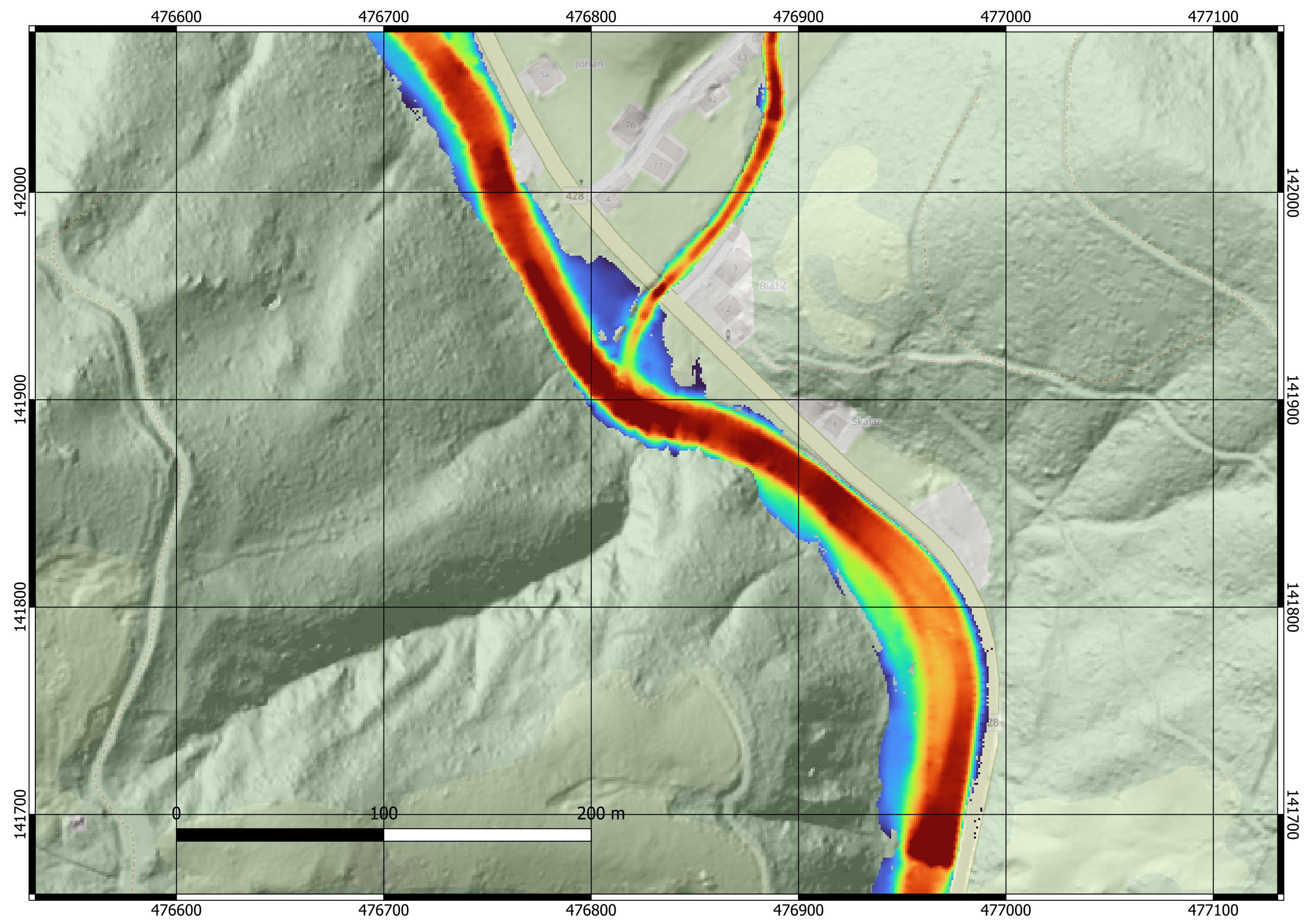
unobstructed channel
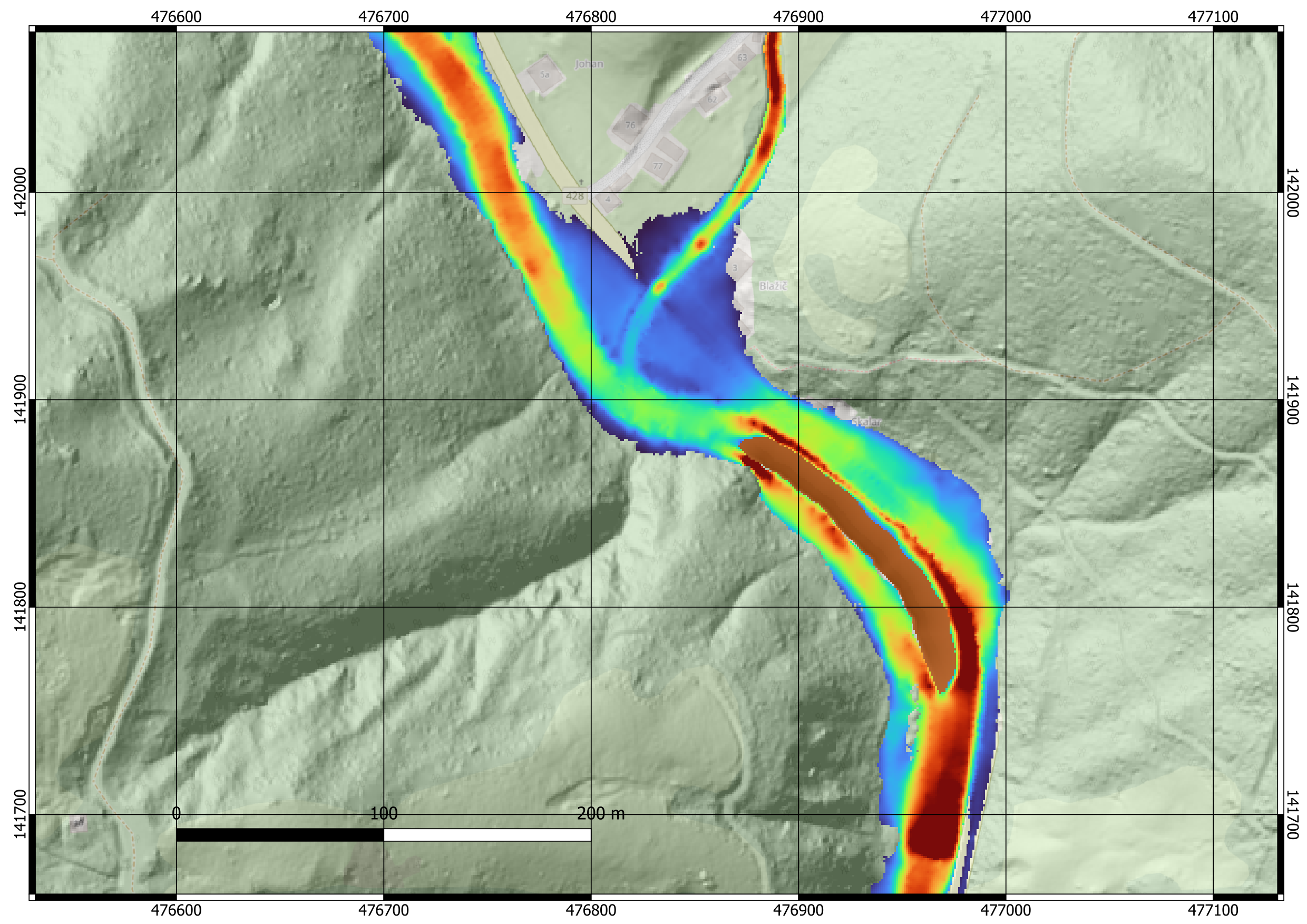
channel obstructed by landslide material

Earth Observation and geospatial data behind the analysis
Earth Observation data provide an important source of information for the development and updating of the digital twin. Satellite data enable frequent monitoring of changes in the environment and built-up areas, while airborne surveys provide highly detailed spatial information.
In this case, the data used primarily include high-resolution datasets acquired through airborne and laser scanning, together with orthophoto imagery and selected Earth Observation data.
LiDAR enables the generation of a highly detailed digital terrain model. The point cloud can be used to determine the shape of the ground surface, the height of objects and other terrain characteristics.
Used for terrain modelling, river-channel geometry, identification of buildings and objects, 3D building models, and inputs for landslide and flood modelling.
Orthophotos provide a spatially accurate representation of the actual surface conditions. They can be used to identify changes, validate modelling results, and visually interpret landslides, watercourses, buildings and other infrastructure.
Satellite Earth Observation data enable frequent monitoring of larger areas. Their main advantage is the possibility of repeated acquisition, which supports the monitoring of changes over time and the updating of data layers within the digital twin.
From observations to simulation
High-resolution geospatial and Earth Observation data provide the spatial foundation for the digital twin. They support terrain and river-channel modelling, identification of buildings and infrastructure, preparation of landslide scenarios and hydraulic flood simulations, and the visual interpretation and validation of model results.
Contributions
Contributing partners