Case Study 2
WhereIsWater Application
Operational identification of recurrently flooded karst landscapes using WhereIsWater for the period 2015–2024.
The Challenge
Intermittent karst lakes are among the most flood-prone agricultural landscapes in Slovenia. Water can repeatedly appear in the same areas within short time periods, while remaining absent for much of the year.
This dynamic behaviour creates uncertainty for farmers and decision-makers. Agricultural land registries and compensation schemes often rely on static classifications that do not reflect the true frequency of flooding. As a result, land that is regularly inundated may be treated the same as land that floods only occasionally, leading to inefficient land-use decisions and disputes over eligibility for agricultural support.
A consistent, objective, and long-term view of flood occurrence was needed.

The Solution: WhereIsWater
WhereIsWater is an operational application that continuously analyses Sentinel-1 radar data to detect surface water bodies across Slovenia.
The application performs regular, nationwide water-body detection independently of cloud cover and illumination conditions. By systematically recording water presence through time, WhereIsWater provides a unique long-term archive of flood events and water dynamics. Withing the Digital Twin of Slovenia WhereIsWater was significantly upgraded and integrated into the platform.
For this use case, WhereIsWater serves as the primary data source, enabling flood frequency analysis over a ten-year period (2015–2024) for selected intermittent karst lakes.
How It Works
The WhereIsWater combines automated satellite processing with temporal aggregation and validation:
This operational setup ensures consistency, repeatability, and scalability.
Results and Impact
Flood frequency mapping was applied to Radensko polje, Planinsko polje, and the Ljubljana marsh. The results support transparent differentiation between occasional and frequently flooded land, enabling more consistent land classification and improved decision-making.
A) Radensko Polje

The biggest detected floods of Radensko polje
Flooding is spatially concentrated in well-defined depressions, clearly delineating zones of recurrent inundation. These areas exhibit limited suitability for stable agricultural use and can be objectively distinguished from land affected only during rare flood events.

Occurrence of floods for Radensko polje
B) Planinsko Polje

The biggest detected floods of Planinsko polje
Flood occurrence is strongly influenced by karst hydrology and river backwater effects. Recurrent inundation zones align with known hydrological pathways. Frequency-based mapping enables consistent spatial differentiation of flood-prone land.

Occurrence of floods for Planinsko polje
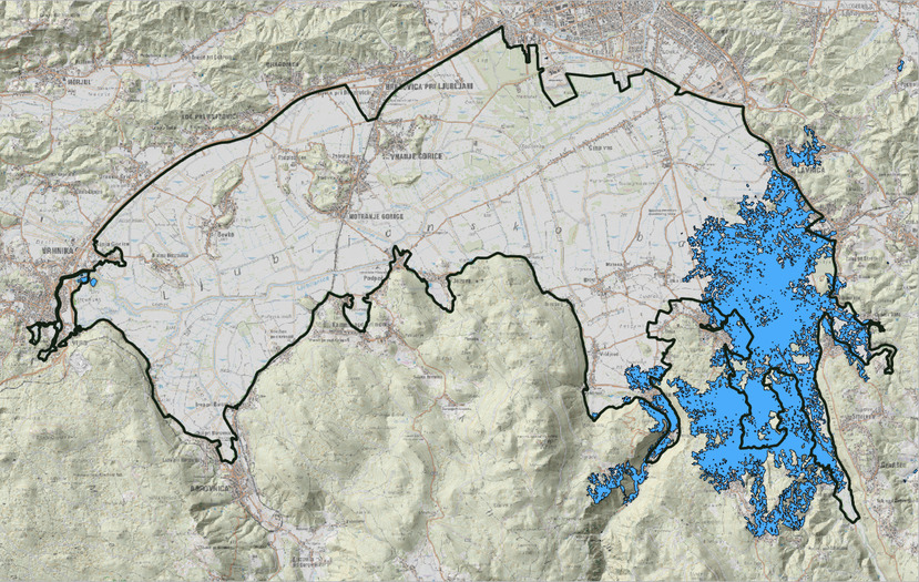
C) Ljubljana Marsh (Ljubjnasko barje)

The biggest detected floods of Ljubljana Marsh
Flooding occurs frequently but unevenly across the landscape. Water occurrence mapping reveals strong spatial heterogeneity. Results support differentiation between regularly flooded areas and land affected only during extreme events. Extreme meteorological events have a direct and immediate effect on flooding.

Occurrence of floods for Ljubljana Marsh
Why It Matters
By transforming repeated satellite detections into flood frequency maps, WhereIsWater turns episodic flooding into actionable spatial evidence.
The approach:
Known Limitations and Mitigation Measures
Two main limitations were identified:
- Snow cover: Early-season and late-season snow can occasionally be misclassified as water. To minimise this effect, the analysis period was limited to April–November and results for April and November were manually verified.
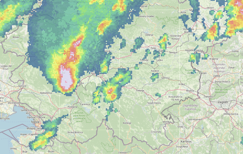
- Extreme rainfall events: In rare cases, intense precipitation at the time of satellite acquisition can temporarily resemble surface water in radar imagery. Such events were identified and cross-checked using meteorological and precipitation radar data.
Example: Ljubljana Marsh extreme weather event on the 6th of August 2017 caused the biggest single flood event detected in the past 10 years.
Known Limitations and Mitigation Measures
Detected water bodies correspond to rain flow patterns
Transferability
Because WhereIsWater operates at national scale and relies on routinely available Sentinel-1 data, the methodology is fully transferable to:
The system supports continuous updates as new satellite data become available.
Developed by: GeoCodis Ltd. All rights reserved